GLASNEVIN
SORRY FOR THE DELAY
-
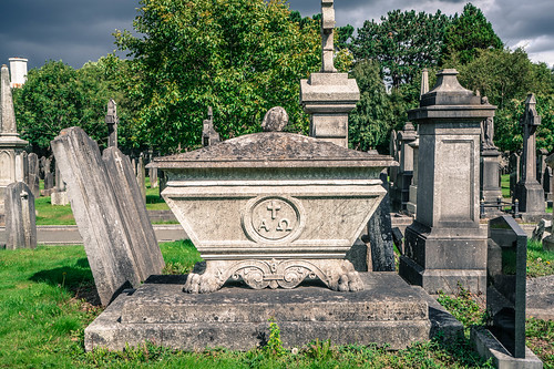
GLASNEVIN CEMETERY
-
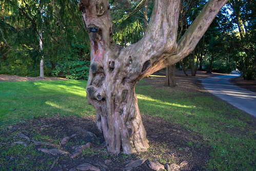
VISIT THE BOTANIC GARDENS
-

SCULPTURE IN CONTEXT
A mainly residential neighbourhood, it is located on the Northside of the city of Dublin. It was originally established on the northern bank of the River Tolka. It is bordered to the north by Finglas, northeast by Ballymun and Santry, Whitehall to the east, Phibsboro and Drumcondra to the south and Cabra to the west.
A mainly residential neighbourhood, it is located on the Northside of the city of Dublin. It was originally established on the northern bank of the River Tolka. It is bordered to the north by Finglas, northeast by Ballymun and Santry, Whitehall to the east, Phibsboro and Drumcondra to the south and Cabra to the west.
Glasnevin is a largely residential middle-class neighbourhood of Dublin, Ireland. Glasnevin is also the seat of Dublin City University with three campuses located on Ballymun Road, Griffith Avenue and Old Finglas Road. The University also has a campus in Drumcondra and another in City West.
Glasnevin seems to have been founded by Saint Mobhi (sometimes known as St Berchan) in the sixth (or perhaps fifth) century as a monastery. His monastery continued to be used for many years afterwards - St. Colman is recorded as having paid homage to its founder when he returned from abroad to visit Ireland a century after St Mobhi's death in 544. St. Columba of Iona is thought to have studied under St. Mobhi, but left Glasnevin following an outbreak of plague and journeyed north to open the House at Derry. There is a long street (Iona Road) in Glasnevin named in his honour. The church on Iona Road is called Saint Columba's.
A settlement grew up around this monastery, which survived until the Viking invasions in the eighth century. After raids on monasteries at Glendalough and Clondalkin, the monasteries at Glasnevin and Finglas were attacked and destroyed.
By 822 Glasnevin, along with Grangegorman and Clonken or Clonkene (now known as Deansgrange), had become the farm for Christ Church Cathedral and it seems to have maintained this connection up to the time of the Reformation.
The Battle of Clontarf was fought on the banks of the River Tolka in 1014 (a field called the bloody acre is supposed to be part of the site). The Irish defeated the Danes in a battle, in which 7,000 Danes and 4,000 Irish died.
The 12th century saw the Normans (who had conquered England and Wales in the eleventh century) invade Ireland. As local rulers continued fighting amongst themselves the Norman King of England Henry II was invited to intervene. He arrived in 1171, took control of much land, and then parcelled it out amongst his supporters. Glasnevin ended up under the jurisdiction of Finglas Abbey. Laurence O'Toole, Archbishop of Dublin, took responsibility for Glasnevin. It became the property the Holy Trinity (Christ Church Cathedral).
In 1240 a church and tower was reconstructed on the site of the Church of St. Mobhi in the monastery. The returns of the church for 1326 stated that 28 tenants resided in Glasnevin. The church was enlarged in 1346, along with a small hall known as the Manor Hall.
When King Henry VIII broke from Rome an era of religious repression began. During the Dissolution of the Monasteries, Catholic Church property and land was appropriated to the new Church of England, and monasteries (including the one at Glasnevin) were forcibly closed and fell into ruin. Glasnevin had at this stage developed as a village, with its principal landmark and focal point being its "bull-ring" noted in 1542.
By 1667 Glasnevin had expanded - but not by very much; it is recorded as containing 24 houses. The development of the village was given a fresh impetus when Sir John Rogerson built his country residence, "The Glen" or "Glasnevin House" outside the village.
A Protestant church, St. Mobhi's, was built in the mid 17th century and most of it was rebuilt in the mid 18th century. It was part of a site where the ancient monastery of St. Mobhi once stood. It is said that Robert Emmet is buried there. This claim is made because once somebody working in the graveyard there dug up a headless body.
The plantations of Ireland saw the settlement of Protestant English families on land previously held by Catholics. Lands at Glasnevin were leased to such families and a Protestant church was erected there in 1707. It was built on the site of the old Catholic Church and was named after St. Mobhi. The attached churchyard became a graveyard for both Protestants and Catholics.
By now Glasnevin was an area for families of distinction - in spite of a comment attributed to the Protestant Archbishop King of Dublin that "when any couple had a mind to be wicked, they would retire to Glasnevin". In a letter, dated 1725 he described Glasnevin as "the receptacle for thieves and rogues. The first search when anything was stolen, was there, and when any couple had a mind to retire to be wicked there was their harbour. But since the church was built, and service regularly settled, all these evils are banished. Good houses are built in it, and the place civilised." Glasnevin National School was also built during this period
Glasnevin became a township in 1878 and became part of the City of Dublin in 1900 under the Dublin Boundaries Act when it received the Royal Assent on August 6, 1900.
The parish population was recorded as 1,001, of whom 559 resided in the village. Glasnevin was described as a parish in the barony of Coolock, pleasantly situated and the residence of many families of distinction.
When Drumcondra began to rapidly expand in the 1870s, the residents of Glasnevin sought to protect their district and opposed being merged with the neighbouring suburb. One of the objectors was the property-owner, Dr Gogarty, the father of the Irish poet, Oliver St. John Gogarty.
On 1 June 1832, Charles Lindsay, Bishop of Kildare and Leighlin and the William John released their holdings of Sir John Rogerson's lands at Glasnevin, (including Glasnevin House) to George Hayward Lindsay. This transfer included the sum of 1,500 Pounds Sterling. Although this does not specifically cite the marriage of George Hayward Lindsay to Lady Mary Catherine Gore, George Lindsay almost certainly came into the lands at Glasnevin as a result of his marriage.
George Hayward Lindsay's eldest son, Lieutenant Colonel Henry Gore Lindsay, was in possession of his father's lands at Glasnevin when the area began to be developed at the beginning of the twentieth-century. The development of his lands after 1903/04 marked the start of the gradual development of the area.
Glasnevin remained relatively undeveloped until the opening up of the Carroll Estate in 1914, which saw the creation of the redbrick residential roads running down towards Drumcondra. The process was accelerated by Dublin Corporation in the 1920s and the present shape of the suburb was firmly in place by 1930. Nevertheless, until comparatively recent years, a short stroll up the Old Finglas Road brought you rapidly into open countryside.
The start of the 20th century also saw the opening of a short lived railway station on the Drumcondra and North Dublin Link Railway line from Glasnevin Junction to Connolly Station (then Amiens Street). It opened in 1906 and closed at the end of 1907. Glasnevin railway station opened on 1 April 1901 and closed on 1 December 1910.
MAJOR IRISH CITIES